HURRICANE STEERING
On the morning of October 19, 2005, Wilma became the most powerful Atlantic hurricane in recorded history. The $64,000 question from the residents of Central America, Mexico and the US Gulf Coast was--where is this monster going to make landfall?
|
Five-day warning cone issued by the National Hurricane Center at 11am on October 19, 2005. Most of Florida is within the warning area. |
In an effort to satisfy such concerns and warn the likely areas of landfall, the NHC issues three-day and five-day warning cones projecting the cyclone's path. The five-day cone issued at 11am on October 19 (right), predicted that Wilma would brush the Yucatan peninsula, pass to the northwest of Cuba and make landfall along Florida's southwest coast.
Although NHC warning cones are familiar, undue focus is frequently placed on the center line instead of the wider danger area intended by the NHC. Although accuracy has improved, forecasting the exact path and timing of a hurricane is an extremely difficult task. The widening of the cone over the forecast period visualizes the increased uncertainty of the storm's path over time. Anyone residing within the shaded cone needs to respect and prepare for the destructive force of an approaching hurricane well in advance of its arrival.
Steering Components
Hurricanes are tall atmospheric features
that extend vertically from the surface to a height of 12,000 meters
(39,000 feet). It is possible to forecast the forward speed and
direction of a hurricane by examining the average direction and speed of
the wind between 850mb (1,500 meters) and 200mb (10,500 meters).
The mean wind speed and direction resulting from this analysis is referred to as the mean steering
current.
However, since a hurricane significantly impacts the wind near to it,
meteorologists assess the mean steering current at a distance of
approximately 300 nautical miles from the storm. This distance can be
easily calculated on a weather map by recalling that 1 degree of
latitude equals 60 nautical miles.
Most tropical progs contain a panel that offers a prediction of the storm's mean steering current. The examples below, from the CMC model (Figure 1) and the NoGaps model (Figure 2), both valid at 8pm on October 20th, predicted that the mean wind speed affecting Wilma's movement would be 10 knots or less from a easterly or northeasterly direction. Wilma drifted west-northwest at 7 to 8 mph during the period.
|
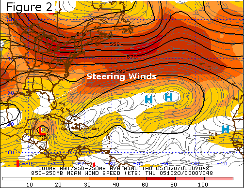 |
(Left) CMC prog of 850-250mb mean wind speed initialized on October 18, 2005 at 8pm and valid at 8pm on October 20, 2005 (full prog image). (Right) NoGaps prog of 850-250mb mean wind speed initialized on October 18, 2005 at 8pm and valid at 8pm on October 20, 2005 (full prog image) The winds steering Wilma were 10 knots or less from the east-northeast. Images from the Penn State Tropical Ewall. |
|
Conditions at the 500mb level, located at approximately half-way point of our atmosphere, often serve as an indicator of the average condition of an air column. Using this fact, meteorologists frequently use wind speed and direction at this level to determine the mean steering winds of a hurricane. The charts of mean 500mb vector wind for October 19 (Figure 3) and October 20 (Figure 4) show that Wilma's steering winds were from a northerly direction and less than 10 meters per second as it slowly drifted towards the Yucatan Peninsula.
 |
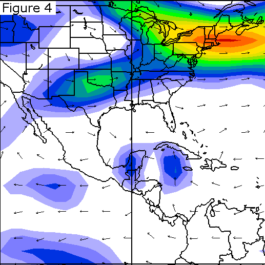 |
(Left) Mean vector wind at 500mb for October 19, 2005 (full image). (Right) Mean vector wind at 500mb for October 20, 2005 (full image). The winds at 500mb, representative of Wilma's steering currents, were less than 10 meters per second. Images provided by the NOAA-CIRES Climate Diagnostics Center, Boulder, Colorado. |
|
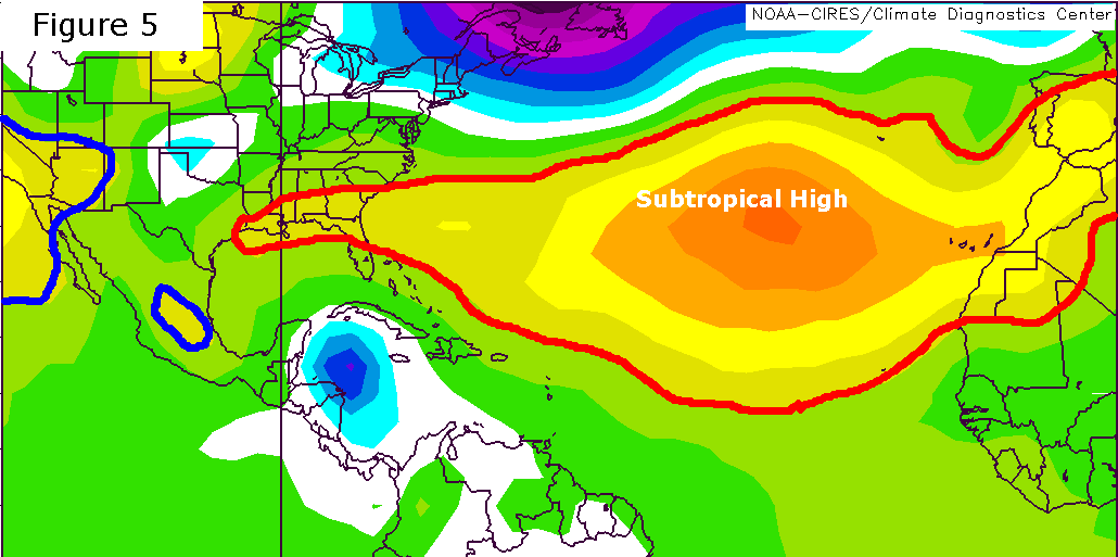
As was discussed in the climatology section, the path of an Atlantic hurricane is influenced by the extent of the semi-permanent Atlantic subtropical high. As indicated on the charts of mean sea level pressure on October 19th (Figure 5) and October 20th (Figure 6), the subtropical high (roughly identified by the red outline of the 1015mb isobars) extended well over the southeastern United States and acted to keep Wilma on a predominantly westerly course. Also note the areas of high pressure over Mexico and the southwestern United States (outlined in blue) impeding Wilma's westward advance. A prolonged collision between Wilma and the Yucatan Peninsula was all but inevitable.
|
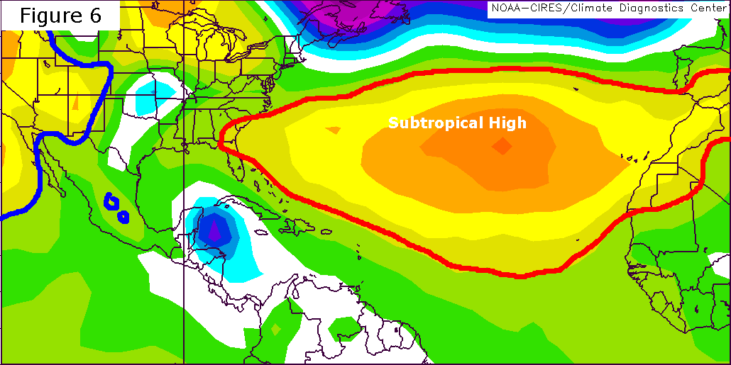 |
(Left) Mean sea level pressure for October 19, 2005 (full image). (Right) Mean sea level pressure for October 20, 2005 (full image). The subtropical high's extension over the southeastern United States prevented Wilma from assuming a northerly path. The 1015mb isobar of the Atlantic subtropical high has been outlined in red for illustrative purposes. Images provided by the NOAA-CIRES Climate Diagnostics Center, Boulder, Colorado. |
|
Track Predictions
The wealth of data on the steering
currents and the nature of the subtropical high shouldn't create the
impression that forecasters are able to pinpoint a hurricane's movement.
The output from the Geophysical Fluid Dynamics Laboratory (GFDL) model
initialized at 2am on October 18, 2005 is illustrative of the
difficulty of this task.
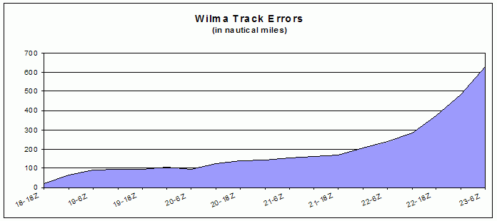 |
Track forecast errors based upon the GFDL model initialized at 2am on October 18, 2005. By 2am on October 23rd, the forecast was off by nearly 600 nautical miles. GFDL data collected from the Penn State Tropical Ewall. Wilma's actual position was obtained from the National Hurricane Center. |
The graph above compares the predicted and actual location of Wilma from 2pm on October 18th to 2am on October 23rd and displays the cumulative error in nautical miles. Wilma was predicted to have made landfall near Tampa, Florida and have emerged into the Atlantic Ocean by 1am on October 23rd. Instead, the storm was 600 nautical miles "behind schedule" off the coast of the Yucatan Peninsula. While the GFDL model did a reasonable job of predicting the path that Wilma would follow, it clearly missed the weak steering currents early in the forecast period that allowed the storm to get hung up over Mexico.
The Hazards of Weak Steering Currents
Weak steering currents allow hurricanes to follow
erratic paths, as was dramatically shown by the antics of Hurricane Ophelia. The weak steering winds associated with Wilma
essentially stalled it over Cozumel and the Yucatan Peninsula for the better part of
two days. By using a satellite based radar system capable of assessing precipitation
rates, NASA's Tropical Rainfall Measuring Mission (TRMM) calculated that Wilma
delivered approximately 12 to 16 inches of rain to Cozumel and the Yucatan
Peninsula on October 21, 22 and the 23rd. The chart below shows the distribution
of rainfall associated with Wilma during its approximately one week lifespan.
|
Radar-derived precipitation totals from the Tropical Rainfall Measuring Mission (TRMM) (full image). Wilma-related precipitation over Cozumel and the Yucatan Peninsula exceeded 12.8 inches. Image from NASA. |
The Westerlies Rescue The Yucatan Peninsula
Mid-latitude weather systems invading the tropics
can fundamentally alter the steering environment of a hurricane. Beginning on
October 23rd and continuing into the 24th, stronger westerly winds associated with
a mid-latitude cold front, combined with the retreat of the Atlantic subtropical
high, shifted Wilma's path to the northeast. Forward speed, in the range of 2 to
5mph during the several previous days, increased to 18 to 20mph as Wilma was
swept towards Florida.
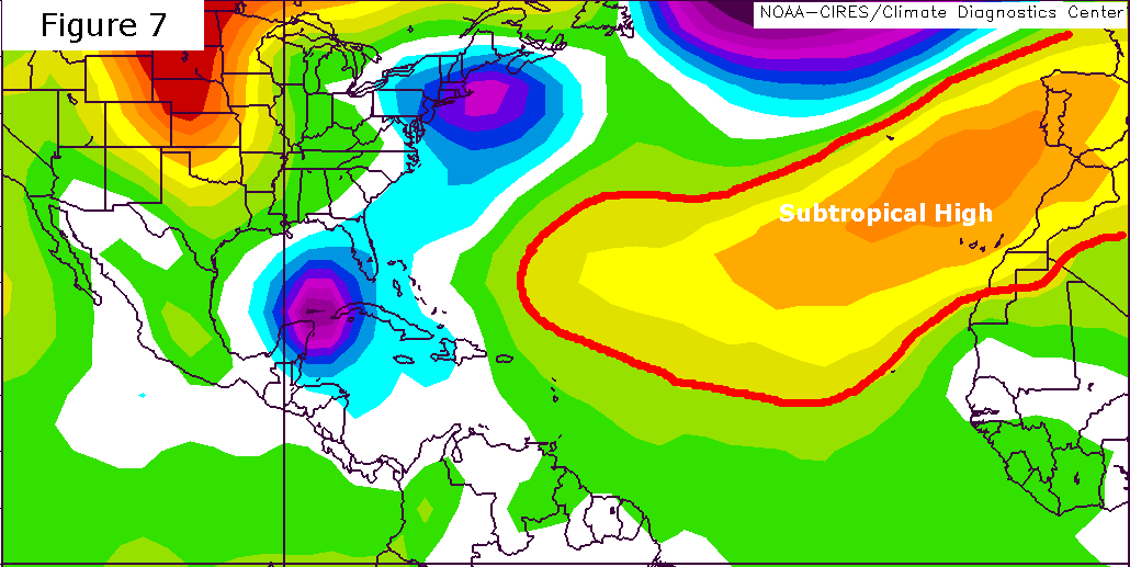
By October 23rd (Figure 7), the Atlantic subtropical high had retreated significantly from its previous configuration on October 19 (Figure 5), allowing Wilma to assume a northeastward track. This tendency of hurricanes to assume a northeasterly track is referred to as recurvature.
 |
|
(Left) Mean sea level pressure for October 19, 2005 (full image). (Right) Mean sea level pressure for October 23, 2005 (full image). Note the significant contraction of the subtropical high by October 23, 2005. The 1015mb isobar of the Atlantic subtropical high has been outlined in red for illustrative purposes. Images provided by the NOAA-CIRES Climate Diagnostics Center, Boulder, Colorado. |
|
Wilma's forward speed increased in response to a southern dip in the mid-latitude westerlies. The charts of mean 500mb wind on October 19 (Figure 3) and October 24 (Figure 8) show the region of much higher wind speed that dipped southward over the Gulf of Mexico.
 |
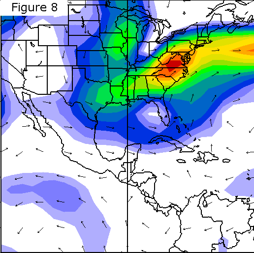 |
(Left) Mean vector wind at 500mb for October 19, 2005 (full image). (Right) Mean vector wind at 500mb for October 24, 2005 (full image). The mid-latitude westerlies had dipped to the south and significantly increased Wilma's steering winds to 15 meters per second (33 mph). Images provided by the NOAA-CIRES Climate Diagnostics Center, Boulder, Colorado. |
|
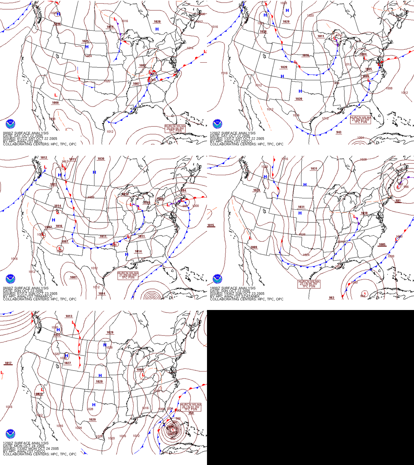
Below is an animation that shows the interaction between two cold fronts from two separate mid-latitude cyclones sweeping south across the Gulf of Mexico and Hurricane Wilma. Note how Wilma moves parallel to the trough toward Florida.
|
Surface analysis maps from October 22 to October 24, 2005. Compiled from images from NOAA. |


