Severe Thunderstorm Ingredients
The development of a thunderstorm is dependent upon three primary ingredients: atmospheric instability, moisture and a lifting mechanism. Severe thunderstorms, and supercell thunderstorms in particular, also require vertical wind shear.
Atmospheric Instability
An unstable air column is characterized by progressively colder temperatures with increasing height. A textbook example of an unstable air mass is characterized by a thick layer of warm moist air at the surface and very cold and dry air higher aloft. In contrast, a stable air mass exhibits a temperature profile that cools very little or not at all with increasing height. A temperature inversion is the peak of stability and marks a layer of the atmosphere where the air aloft is warmer than the air below it. Lapse rate is the term used to quantify the rate of this temperature decrease. On average, the temperature declines approximately 6.5° C for each 1,000 meters in increased height and is known as the average environmental lapse rate.
The development of severe thunderstorms is dependent upon air parcels remaining positively buoyant throughout a deep layer of the atmosphere. By definition, a positively buoyant rising air parcel is warmer and therefore less dense than the environment in which it is located. The arrival of cold air associated with an upper level trough, or the extreme heating of air near the surface can, significantly contribute to the instability of an air column by increasing the lapse rate between air near the surface and air aloft.
Moisture
The Gulf of Mexico and the Atlantic and Pacific oceans are the primary sources of moisture fueling outbreaks of severe weather in the continental United States. Moisture, in the form of water vapor, contributes to the potential buoyancy of an air parcel in two ways. First, a water molecule weighs less than an air molecule, therefore an air parcel that contains water vapor is lighter and more buoyant than a dry parcel. Second, during ascent, a moist air parcel cools at a slower rate (6° C per 1,000 meters) than a dry parcel (10°C per 1,000 meters). This differential, created by the latent heat of condensation, results in a moist parcel remaining warmer and more buoyant than its surrounding environment. An air column characterized by a temperature decrease approaching 10° per 1,000 meters of height is said to have a "steep" lapse rate. A decrease of 10° C per 1,000 meters is referred to as the dry adiabatic lapse rate, while a lapse rate of 6° C is known as the moist adiabatic lapse rate.
Lifting Mechanisms
Even with abundant moisture and an unstable environment, a lifting mechanism is required to initiate upward motion in an air column. The cold and warm fronts comprising a mid-latitude cyclone are frequently a source of lift, the nature of which is shown in the two graphics below.
 |
 |
|
Cold front graphic from the COMET Program. |
Warm front graphic from the COMET Program. |
As represented in the cross section of a cold front (above left), the wedge of dense cold air and the converging winds along the frontal boundary are an excellent lifting mechanism. Warm fronts can also be a source of lift, but as the graphic (above right) indicates, the lifting associated with a warm front tends to be less abrupt as the warm air overuns the retreating cold air mass. However, the potential for severe thunderstorms exists in the vicinity of both frontal boundaries.
 |
|
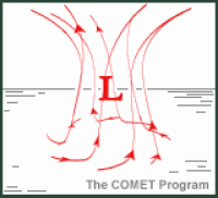
Air flow in a northern hemisphere low pressure system. Image from the COMET Program. |
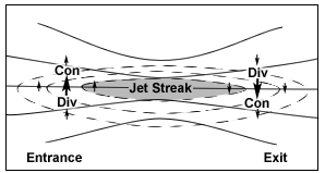
In addition to frontal boundaries, features in the upper atmosphere such as jet streaks (pockets of significantly stronger winds traveling through the flow) and short-wave troughs (kinks in the overall wave pattern) can contribute to lowering surface pressure and upward motion in an air column by shedding mass in the upper atmosphere.
The graphic to the left shows the air flow associated with a northern hemisphere low pressure system. The converging flow of air towards the low's center (the flow is counter-clockwise) promotes the rising of air parcels. At higher levels in the atmosphere, these air parcels are exhausted away from the air column in a clockwise (anticyclonic) flow. This shedding of mass, called upper-level divergence, must exceed the mass being added by convergence at the surface in order for an area of surface low pressure to intensify.
Vertical Wind Shear
The change in either the speed or direction of the wind with increasing height is referred to as vertical wind shear. The graphic below provides a very simple one-dimensional example of wind shear (the direction at all levels is west). The wind 1 kilometer above the surface is blowing at a speed of 5 knots while at a level of 4 kilometers the wind speed is 20 knots. In this example, the value of wind shear between 1 kilometer and 4 kilometer would be 15 knots.
 |
|
A graphic example of vertical wind shear. |
Vertical wind shear contributes to severe thunderstorms by contributing a tilt to the storm that allows the updraft and downdraft to remain separate. Lacking sufficient vertical wind shear, the updraft -- critical for the storm's existence -- would be choked off by the cold air of the downdraft. Vertical wind shear also contributes to the potential for the creation of tornadoes by imparting spin to an air column.
Next: A Primer on Skew-Ts and Hodographs
Back: Introduction
© 2005-2006 Mark A. Thornton