INTRODUCTION
A Brewing Storm
A darkening sky, rumbles of thunder, rain and strong winds announce the arrival of severe thunderstorms to those unfortunate enough to live in their path. The National Weather Service defines a severe thunderstorm as wind or gusts greater than 50 knots, hail equal to or greater than 3/4" in diameter, or a storm that produces at least one tornado. Because of the potential for injury and death, the mission of the Storm Prediction Center (SPC) and local National Weather Service (NWS) offices is to provide sufficient notice of approaching severe weather to enable residents to take steps to protect their life and property.
At mid-day on February 16, 2006, when residents of the lower Midwest began receiving notice of approaching foul weather, they were reaping the benefit of a substantial amount of careful and complex analysis that began several hours before.
Convective Outlooks
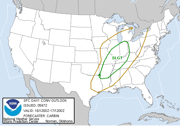
The SPC, located in central Oklahoma, was several hundred miles away from the action on February 16th. But its Day 1 Convective Outlook issued at 613 AM CST on February 16, 2006, stated:
There Is A Slight Risk Of Severe Thunderstorms Across Much Of The Mid MS And OH Valleys;
Morning Water Vapor Imagery Shows Strong Shortwave Trough Over CO. This Feature Is Forecast To Propagate Eastward Across The Central Plains States And Mid MS/OH Valleys Today. Upper System Is Also Expected To Intensify Significantly This Afternoon And Tonight; With 110+ Knot Mid Level Speed Max Nosing Across IL/IN. Primary Surface Low Will Track From The TX Panhandle Into Northern IL By Late This Afternoon; Then Across MI Tonight. Very Strong Southwesterly Low Level Winds /60-80 Knots At 850mb/ Will Develop Ahead Of Low Across Much Of The OH/TN/mid MS Valleys; Transporting Moist And Marginally Unstable Air Mass Northward.
Present Indications Are That Line Of Strong Thunderstorms Will Develop Along Surface Cold Front During The Mid/late Afternoon From Central IL Into Northeast AR. This Activity Will Quickly Organize Into A Squall Line And Spread Eastward Across Parts Of IN/OH/KY/TN During The Evening. Very Strong Wind Fields; Coupled With Sufficient Instability And Forcing Along The Front Will Favor Locally Damaging Winds And Hail In Stronger Cells. Model Guidance Also Shows Higher Low Level Theta-e Values Across Parts Of Western KY/TN This Evening; Resulting In Slightly Higher Convective Available Potential Energy Values. Orientation Of Deep Layer Shear Vectors Also Suggest A Higher Potential For Discrete Convective Organization; Along With A Greater Threat Of Sustained Supercells And Isolated Tornadoes. Squall Line May Move As Far East As Eastern OH Overnight With A Continued Threat Of Damaging Winds...
The Day 1 Convective Outlook is issued by the SPC five times each day, and in contrast to forecasts issued by local NWS offices, is not intended for the general public. Instead, it provides the meteorological community with a concise technical summary of the atmospheric dynamics anticipated to contribute to a severe weather outbreak.
In addition to a written summary, the Convective Outlook includes graphics displaying the probability that a particular element of severe weather will develop across the country. The series of images below display these probabilities for February 16, 2006. These elements include the probability of:
-
a tornado within twenty-five miles of a point
-
hail equal to or greater that 3/4" in diameter within twenty-five miles of a point
-
sustained wind or a wind gust greater than fifty knots within twenty-five miles of a point
|
|
||||
|
Probability Graphics issued at 1213Z (6AM CST) by the SPC. |
||||
| Convective Outlook Graphics | Overview | Tornado | Hail | Wind |
Storm Reports
The SPC also acts as the repository for reports of damage caused by hail, high wind or tornadoes associated with severe storms. Most of the these reports are submitted to local NWS offices by trained storm spotters and emergency management personnel. The local NWS offices, in turn, forward the data to the SPC where it becomes one of the tools used to measure the accuracy of SPC forecasters.
The graphic below shows the storm reports received for the events of February 16, 2006. Tornado reports are identified by red dots, high wind reports by blue dots and hail reports by green dots.
|
|
|
SPC Storm Reports For February 16, 2006. |
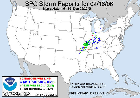
The storms were responsible for:
-
four tornado sightings, two in Missouri and two in Illinois
-
fifty-six reports of high wind spread across Arkansas, Missouri, Illinois, Kentucky and Michigan
-
sixty-two reports of hail in Arkansas, Missouri, Illinois, and Indiana
A review of the events on February 16th in light of the 613 AM Day 1 Convective Outlook suggests the SPC did an excellent job of predicting the severe weather outbreak. Before we investigate some of the atmospheric variables they analyzed, let's review the ingredients necessary for the formation of a severe thunderstorm.
Next: Thunderstorm Ingredients
Restore the Frames Version
© 2005-2006 Mark A. Thornton