Tornado Potential
Being reasonably confident that supercell thunderstorms were likely in south central Oklahoma, SPC forecasters turned their attention to the potential for tornadoes.
Mean Parcel LCL
The Lifting Condensation Level is the pressure level at which a lifted parcel of air reaches saturation when lifted dry adiabatically. On a Skew-T, the mean parcel LCL is identified by using the average temperature and dew point in the lowest 100mb. The intersection of a line drawn parallel to the mixing ratio line from the dew point, and parallel to the dry adiabat from the temperature, is the LCL. The location of the LCL roughly approximates the height of the cloud base when air parcels undergo forced ascent.
|
|
|||
|
100 mb Mean Parcel LCL Height from the SPC. |
|||
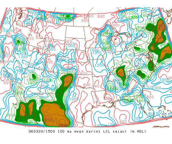
As a forecasting parameter, low LCL heights (in meters) are associated with the development of tornadoes. Statistically, the most destructive tornadoes form when LCL heights are extremely low -- in the four- to six-hundred meter range. On average, both the potential and intensity of tornadoes tends to decrease as the height of the LCL increases. A review of the chart series depicting LCL heights (above), shows a value of six-hundred meters over south central Oklahoma from 15Z to 17Z. This height is very close to the average value for F2 to F5 tornadoes and would have drawn the attention of the SPC.
Storm Relative Helicity
Storm Relative Helicity (SRH) combines the vertical wind structure, motion of the storm and the rate that the storm is ingesting streamwise vorticity into a single forecasting parameter represented in m^2/s^2. As a forecasting parameter it is used to predict the likelihood that an updraft in a right-moving supercell will develop cyclonic rotation.
|
|
|||
|
Surface to 1 Kilometer SR Helicity and storm motion from the SPC. |
|||
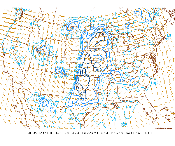
Regions characterized by values of Surface to 1 km Storm Relative Helicity (0-1 km SRH) exceeding one-hundred m^2/s^2 have a greater chance of tornado development. The series of charts of 0-1 km SRH (above) shows that values in south central Oklahoma were in the three- to four-hundred m^2/s^2 range during the period. Research conducted by the SPC shows that such 0-1 km SRH values are statistically correlated with the development of significant tornadoes.
Surface to 1 Kilometer (km) Shear Vector
Surface to 1 Kilometer Shear Vector (0-1km Shear Vector) is the measure of vertical wind shear between the surface and one kilometer. The formation of tornadoes from supercell thunderstorms is more likely when the 0-1 km Shear Vector exceeds a range of fifteen to twenty knots.
|
|
|||
|
Surface to 1 Kilometer (km) Shear Vector from the SPC. |
|||
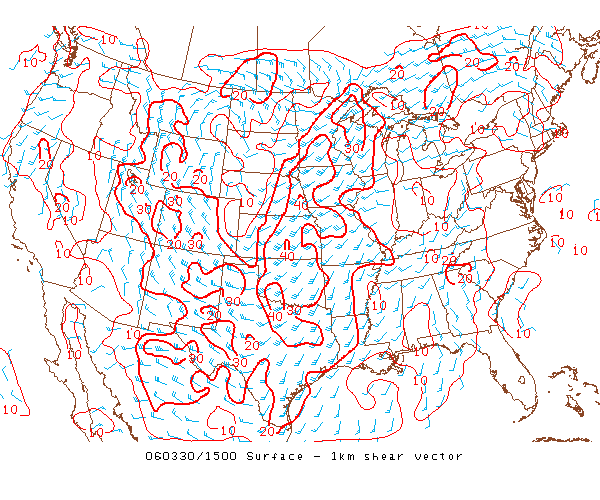
Based on the charts of 0-1 km shear vector (above), the values exceeded thirty knots in south central Oklahoma from 15Z to 17Z. This was supportive of tornado development.
Significant Tornado Parameter
The Significant Tornado Parameter (STP) is calculated by combining five parameters:
-
Effective Bulk Shear, similar to the surface to 6 km vertical shear vector, is the value of the wind shear from the level of the most unstable air parcel up to a height equal to 40-60% of the equilibrium level -- the pressure level at which the lifted parcel becomes colder than its environment, and therefore negatively buoyant.
-
Storm Relative Helicity (SRH) is a measure of the low-level wind shear relative to the movement of a thunderstorm and is used to measure the nature of the storm's rotation.
-
MLCAPE differs from surface-based CAPE in that the lifted parcel begins from an average of the dew point and temperature in the lowest 100mb.
-
MLCIN is a measure of the amount of energy (in joules per kilogram) required to raise an air parcel from the average of the dew point and temperature to the Level of Free Convection (LFC).
-
The Mean Parcel LCL Height, which was discussed above.
|
|
|||
|
Significant Tornado Parameter from the SPC. |
|||
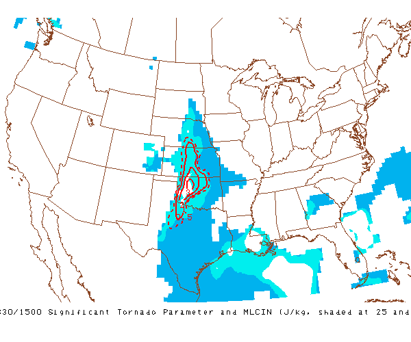
Generally, STP values larger than one are associated with tornadoes rating an F2 or greater. Regions that are less supportive of tornadogenesis typically have STP values less than one. The charts of STP (above) show that values greater than two existed in the western portion of the area that would be included in the watch box.
The tornado-related parameters provided here suggest that conditions were favorable not only for supercell thunderstorms, but tornadoes as well.
Next: Forecasting Parameter Summary
Previous: Analyzing The Potential For Supercell Thunderstorms
© 2005-2006 Mark A. Thornton