Supercell Thunderstorm Potential
Supercell thunderstorms, with their propensity for producing hail, damaging winds and tornadoes, are a constant concern in the lower Great Plains. By mid-morning on the 30th, it was clear to SPC forecasters that thunderstorms were moving east toward south central Oklahoma and severe weather warnings had to appropriately address the potential risk.
Surface to 6 Kilometer Shear Vector
In contrast to air mass thunderstorms, supercell thunderstorms require sufficient vertical wind shear to create a tilt in the storm that separates its updraft from its downdraft. Without such a separation, the storm's cool downdraft would quickly spread out and extinguish the updraft -- the storm's source of energy. One parameter used to forecast the likelihood of supercell development is the Surface to 6 Kilometer Shear Vector (0-6 km Shear). This parameter, measured in knots, is calculated by determining the change in wind speed and direction from the surface to a height of six kilometers, which is just slightly above the standard height at 500mb.
|
|
|||
|
Surface to 6 km Shear Vector (in knots) from the SPC. |
|||
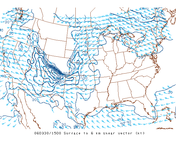
Values of 0-6 km shear in the range of thirty-five to forty knots correlate to well-organized and long-lasting supercell thunderstorms. The series of images (above) shows that early in the period, wind shear values in the future watch box were in the range of 30 to 35 knots and, therefore, not very supportive of supercell development. By 17Z, the 0-6 km shear values had increased to 45 knots with a small region of 50 knots in the northern portion of the watch box. Wind shear became a lot more favorable for supercell development in a little over two hours.
9 to 11 km Storm Relative Winds
An analysis of 9 to 11 km Storm Relative Winds (9-11 km SR Winds) can be used to distinguish which variety of supercell thunderstorms -- low-precipitation (LP), high-precipitation (HP) and classic supercells (CL) -- are likely to develop over a region. Classic supercells, the source of most tornadoes, are likely when the 9-11 km SR winds are between forty and sixty knots. HP supercells are more likely when upper-level storm relative winds are lighter than forty knots. The domain of LP supercells are those regions characterized by upper-level storm relative winds greater than sixty knots.
The 9-11 km SR winds influence supercell type by influencing the distribution of hydrometers as they emerge from the updraft in the upper levels of the storm. The precipitation from HP storms falls in the general area of the updraft because storm relative winds are too light to distribute it downstream. In contrast, the precipitation resulting from LP storms is transported downshear by brisk storm relative winds.
|
|
|||
|
9 to 11 Kilometer Storm Relative Winds (in knots) from the SPC. |
|||
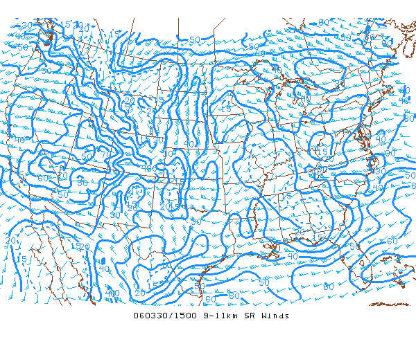
The charts of 9-11 km SR winds (above) indicate that storm relative winds over south central Oklahoma increased from approximately thirty-five knots to nearly fifty knots between 15Z and 17Z. This transition shifted the likely storm type from high precipitation to classic supercells. Since most tornadoes are formed within classic supercells, this was a noteworthy development.
Supercell Composite Parameter
The Supercell Composite Parameter (SCP) is a composite index calculated by combining three forecasting parameters:
-
Storm Relative Helicity (SRH) combines the vertical wind structure, motion of the storm and the rate that the storm is ingesting streamwise vorticity into a single forecasting parameter.
-
Most Unstable Convective Available Potential Energy (MUCAPE) is a calculation of CAPE resulting from the most unstable air parcel in the lowest 300mb of the atmosphere. MUCAPE, as a measure of buoyancy, provides an assessment of the potential for the development of convection.
-
Effective Bulk Shear, similar to the surface to 6 km vertical shear vector, is the value of the wind shear from the level of the most unstable air parcel up to a height equal to 40-60% of the equilibrium level -- the pressure level at which the lifted parcel becomes colder than its environment, and therefore, negatively buoyant.
|
|
|||
|
Supercell Composite Parameter from the SPC. |
|||
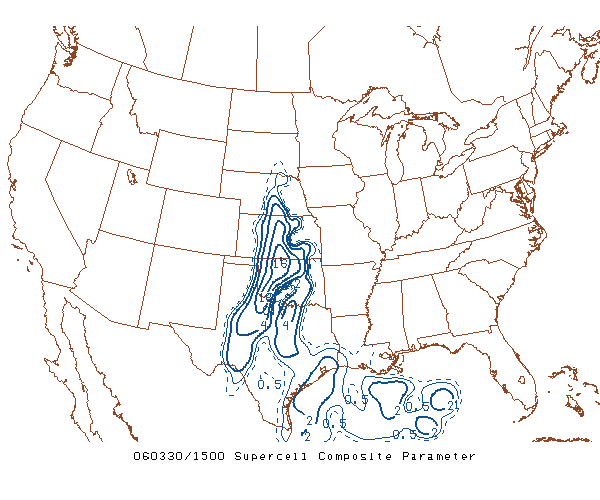
Since each component has a different scale, it is necessary to normalize the values prior to calculating the SCP. The values of SCP can be used as a guideline to discern the potential for the development of supercell or non-supercell thunderstorms, and whether surface-based or elevated supercells are likely to form. The charts of SCP (above) show that early, values of SCP in central Oklahoma ranged from six to ten. By 17Z, the SCP value had increased to 8 to 12 within the watch box area. Based on research from the Storm Prediction Center, values of SCP in this range suggest the development of surface-based supercell thunderstorms.
Significant Hail Parameter
Similar to the SCP, the Significant Hail Parameter (SHIP) is derived from five parameters, and is used to differentiate when "significant hail" is possible. In the context of this parameter, significant hail is defined as equal to or greater than two inches in diameter. The SPC is quick to note that SHIP is NOT a forecast of hail size. The parameters included in the determination of SHIP are:
-
Most Unstable Convective Available Potential Energy (MUCAPE) in j/kg is a calculation of CAPE resulting from the most unstable air parcel in the lowest 300mb of the atmosphere. MUCAPE, as a measure of buoyancy, provides an assessment of the potential for the development of convection.
-
The Mixing Ratio of the Most Unstable Parcel, a measure of the mass of water vapor to the mass of dry air, in grams per kilogram.
-
The rate of temperature change, known as the lapse rate, from 700mb to 500mb in degrees Celsius.
-
The temperature at the 500mb level in degrees Celsius.
-
The 0-6 km shear vector in knots, a parameter described earlier.
|
|
|||
|
Significant Hail Parameter from the SPC. |
|||
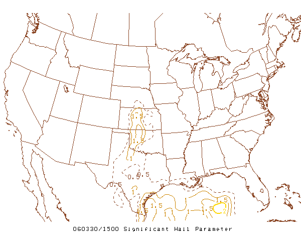
Although SHIP values of 1.0 indicate that conditions are favorable for the development of significant hail, evidence suggests that values of 1.5 to 2.0 are more realistic. Although the SPC made reference to the potential for significant hail (up to 3") in the Tornado Watch, the chart series of SHIP (above) shows that south central Oklahoma was below the 1.5 threshold during the entire period leading up the Watch.
The data available to SPC forecasters in the hours prior to 17Z on March 30th pointed to an outbreak of supercell thunderstorms over south central Oklahoma. The damaging potential of supercell thunderstorms clearly warranted a severe thunderstorm watch, but why did the SPC issue a tornado watch? There are specialized forecasting parameters that help answer this question.
Next: Analyzing The Potential For Tornadoes
Previous: Convective Potential
© 2005-2006 Mark A. Thornton