Convective Environment
In contrast to the relatively weak nature of synoptic scale lifting on March 12, 2006, the thermodynamic conditions were very conducive to the development of severe thunderstorms.
Moisture
The development of severe thunderstorms relies upon an ample supply of warm, moist air. The source of this fuel for storms in the Great Plains and Midwest is predominantly the Gulf of Mexico. This warm, moist air may be transported, or advected, by the wind at lower levels of the atmosphere--a feature known as a low-level jet. The 850mb charts (below) at 6 AM CST and 6 PM CST provide an analysis of wind speed and direction associated with the low-level jet. This flow, particularly at 6 PM, was southerly in the range of 30 to 35 knots.
 |
||
| 850mb Analysis Chart from the SPC- March 12, 2006 | 12Z (6AM CST) | 0Z (6PM CST) |
One measure of the extent of atmospheric moisture is Theta-E, which is meteorological shorthand for Equivalent Potential Temperature. Increases in dew point and temperature result in an increase in the value of Theta-E, therefore high values of Theta-E represent warm moist air. Since warm moist air is often associated with atmospheric instability, forecasters view regions of high Theta-E as ripe for the development of severe weather.
The series of images depicting surface observations (below) shows the relationship between warm temperatures, high dew points and the resulting relatively high values of Theta-E. The temperature in central Illinois at 8 PM CST (2Z on March 13) hovered around 60°F, an unseasonably warm March evening. Dew points at the same hour were in the mid 50's (F). The steep ridge of high Theta-E advancing up the Mississippi Valley into central Illinois shows the combination of the temperature variables.
 |
|||
| Surface observations at 2Z on March 13 (8PM CST 3/12) from the Plymouth State Weather Center. | Temperature | Dew point | Theta E |
The 02Z chart (8PM CST on 3/12) depicting Theta-E and Theta-E advection (below) shows that not only were Theta-E values relatively high in central Illinois, but also that the supply of warm, moist air was increasing. In fact, the maximum Theta-E advection occurring at the time was spread across northern Missouri and central Illinois.
 |
|
Theta-E advection at 2Z on 3/13/2006 (8PM CST 3/12) from the SPC (full image). |
Another method of determining the availability of moisture is to analyze a chart of deep moisture convergence such as the one below from 2Z (8PM CST on 3/12). The values on the chart represent the result of a formula that combines the effect of moist air advection and converging winds. High values of moisture convergence indicate that fuel, in the form of moist air, is increasing in an area and raising the potential for thunderstorm development. Central Illinois was encompassed by a lobe of elevated deep moisture convergence.
 |
|
Deep Moisture Convergence at 2Z on 3/13/2006 (8PM CST 3/12) from the SPC (full image). |
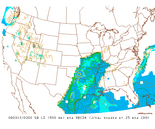
Lifted Index
The Lifted Index (LI) is a relatively simple parameter that reflects the difference in temperature at 500mb between the environment and a parcel that has been lifted moist adiabatically (by following the moist adiabat on a Skew-T) from the Lifting Condensation Level (LCL). A negative LI indicates that the lifted parcel is warmer than its environment and positively buoyant. LI values below -5 suggest the possibility for strong convection, while values greater than 0 generally indicate that the risk of severe weather is low.
 |
|
Surface Based Lifted Index and CIN at 2Z on 3/13/2006 (8PM CST 3/12) from the SPC (full image). |
The 02Z (8PM on 3/12) chart of Surface Based LI and Convective Inhibition (CIN) (above) shows the LI in central Illinois was -5, an indicator of an extremely unstable air mass. Convective Inhibition, measured in joules per kilogram (j/kg), refers to that layer of a sounding where a lifted parcel is colder than its environment and negatively buoyant.
This region of negative buoyancy must be overcome before storms can develop. Convective Inhibition (CIN) can be overcome by heating of the air near the surface, moistening of the air near the surface, or synoptic-scale lifting such as a cold-front or upper-level dynamics. Based upon the 02Z chart, CIN values were fairly modest (25-50 j/kg) and presented only a minor impediment to convective development.
Convective Available Potential Energy
Although a useful tool, the Lifted Index measures instability at only a single level (500mb) and therefore may not be representative of the convective potential of the atmosphere. Convective Available Potential Energy (CAPE) is the sum of the positive buoyant energy (in joules per kilogram) a rising surface parcel would possess as it travels from the Level of Free Convection to the Equilibrium Level. In contrast to the Lifted Index, CAPE provides an assessment of the convective potential through a deep layer of the atmosphere.
 |
|
MLCAPE and CIN at 2Z on 3/13/2006 (8PM CST 3/12) from the SPC (full image). |
The chart above, from the SPC's Mesoscale Analysis site, presents the 100mb Mean Layer CAPE (MLCAPE) and Mean Layer CIN (MLCIN) at 02Z (8 PM CST). MLCAPE differs from surface-based CAPE in that the lifted parcel begins from an average of the dew point and temperature in the lowest 100mb. The values of MLCAPE are more realistic than surface-based CAPE when the air near the surface is very moist. A broad region of MLCAPE (outlined in red) of approximately 1000 j/kg extended through Missouri and into central Illinois and suggested an unstable atmosphere.
Skew-T Diagram
Skew-T Diagrams are an indispensable resource in analyzing the overall temperature and wind profile of an air column. In addition to displaying the temperature, dew point and wind at various levels of the atmosphere, a SkewT diagram can be used to determine a number of convective indices used by forecasters to assess the potential for severe weather.
 |
||
| Skew-T diagrams at Lincoln, Illinois on March 12, 2006 from NWS Lincoln, Illinois. | 12Z (6 AM CST) | 00Z (6 PM CST) |
The Skew-T diagrams on March 12, 2006 (above) from Lincoln, Illinois, show the erosion of the inversion just above the surface and the overall destabilization of the air column from 6 AM to 6PM CST.
The variables presented on this page confirm that the thermodynamic conditions were ripe for convective development on March 12th. However, these variables do not provide the ability to predict the type of storms that were likely to develop. There are, however, a variety of forecasting parameters available to forecasters that permit them to warn the public when conditions are favorable for the development of supercell thunderstorms.
Next: Forecasting Supercells
Previous: Synoptic Picture
© 2005-2006 Mark A. Thornton