Synoptic Scale Forecasting: A Primer
Weather Scales
The American Meteorology Society (AMS) defines a synoptic chart as "any chart or map on which data and analysis are presented that describe the state of the atmosphere over a large area at a given moment in time". Most meteorologists consider synoptic analysis to include those weather features that range in size from 1,000 to 10,000 kilometers (621 to 6,213 miles). Larger features are considered to be on the planetary scale while smaller ones are classified as mesoscale. Mesoscale features are further subdivided into:
Mesoscale-α are those features that are 200 to 1,000 kilometers (124 to 621 miles)
Mesoscale-β are those features that are 20 to 200 kilometers (12.4 to 124 miles)
Mesoscale-γ are those features that are 2 to 20 kilometers (1.2 to 12.4)
Daily Weather Forecasts
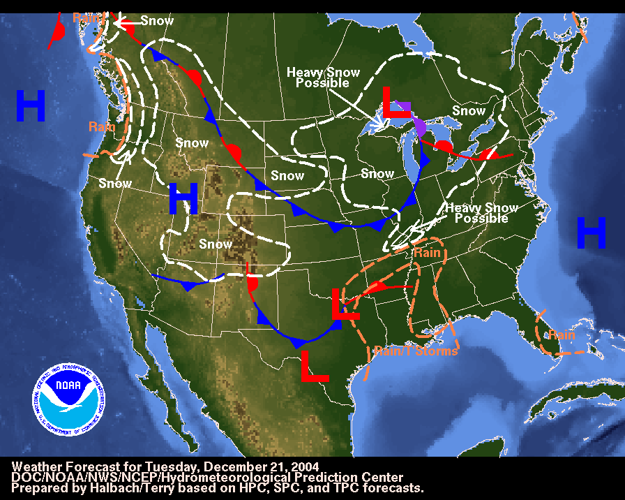
Each day, meteorologists at the Hydrometeorological Prediction Center use current observations of the atmosphere, an understanding of meteorological principles and powerful computer models to produce a synoptic scale national Weather Forecast map such as the one below for December 21, 2004. The forecast map for December 21, 2004 showed an area of low pressure in Texas expected to produce rain and thunderstorms, but the big weather story was the possibility of heavy snow over much of the Midwest emanating from the low pressure system centered over Lake Superior.
In the two days following this forecast, the cold front associated with the low pressure system over Lake Superior swept to the southeast as the low pressure system in Texas traveled northeasterly. A progression of the daily weather forecasts for the next few days can be viewed by scrolling over the date along the top of the map. By December 24th, the entire system had moved into the Atlantic but it would be days before residents of the Ohio Valley would get their lives back in order.
| Forecast Date (Mouseover to change.) |
Dec 21st | Dec 22nd | Dec 23rd | Dec 24th |
 |
|
Weather Forecast map from the Hydrometeorological Prediction Center (HPC) (full image). |
Although no two low pressure systems are identical, either in their path or in the weather they produce, meteorologists have developed a general model of their formation and behavior that helps to guide their forecasts.
Mid-Latitude Cyclones: A Primer
 |
|
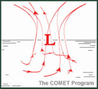
Northern Hemisphere low pressure system from The COMET Program. |
Meteorologists define cyclones as areas of low barometric pressure where the associated surface winds blow in a counterclockwise direction in the Northern Hemisphere and clockwise in the Southern Hemisphere. Mid-latitude cyclones are simply those weather systems that dominant the region between 30° and 60° latitude, an area that includes the United States and most of Canada. Since the approach and passage of a cyclone usually results in lousy weather, they are more commonly referred to as storms.
The graphic to the left shows the overall structure of the center of circulation of a classic Northern Hemisphere low pressure system. An area of low pressure is an air column that contains less mass and therefore weighs less than its surrounding environment. A low pressure is characterized by converging winds that rotate cyclonically (counterclockwise in the Northern Hemisphere) in towards the center. In response to the converging winds, air parcels tend to rise within the air column. The process of condensation associated with this rising air that promotes the development of clouds and precipitation that are so common with cyclones. In order for a cyclone to continue to develop (deepen), a mechanism higher in the atmosphere must remove air from the column faster than it is entering near the surface. This support aloft, referred to as upper-level divergence, is a key contributor to powerful mid-latitude cyclones.
 |
|||||||
| Image | 1 | 2 | 3 | 4 | 5 | 6 | 7 |
|
Formation of a mid-latitude cyclone, images from the COMET Program. (Mouseover stages to change images.) |
|||||||
If atmospheric conditions are favorable, the frontal boundary may take on a kinked appearance as represented in image two. The cold front now pushes south as the warm front pushes north. The intersection of the two fronts is the area of lowest pressure and destined to be the center of the cyclone's circulation.
Image three shows the continued progression of the system and the early development of cyclonic wind flow. Image four shows a fully developed cyclone with both its cold and warm front. As the image shows, the cold front moves at a faster pace than the system's warm front.
In image five, the cyclone's cold front has overrun the warm front and the system is now referred to as occluded. A cyclone is typically at the greatest intensity during the occluded phase but it is also the beginning of the end. As the center of circulation retreats from the warm air, it loses access to its energy supply, namely warm, moist air. In addition, the low which has lost the supporting role of upper-level divergence, takes on mass faster than it is exhausted at the top of the column and surface pressure begins to increase. Image six shows the continued retreat of the cyclone's center and the extension of the occluded front. The center is not entirely surrounded by cool air. Image seven shows the final stage of the cyclone as the center of circulation dissipates.
Four types of fronts may be associated with a mid-latitude cyclone. Stationary fronts, identified on a weather map by alternating red half circles and blue triangles, are either motionless or moving at less than five knots. Under most circumstances, light precipitation is associated with stationary fronts. Cold fronts, represented by blue triangles on a solid blue line on a weather map, identify the zone where cold, dry air collides with and replaces warm, moist air. Because of the dramatic changes in pressure, temperature and humidity that occur along a cold front, it is an area where thunderstorms and winter storms frequently form. The cold front animation (below left) demonstrates the wedge-like action of the cold air as it drives forward under the warm air. As the animation shows, the result is often towering cumulus clouds. A cyclone's most volatile weather is usually associated with its cold front.
 |
 |
|
Cold and warm front animations from The COMET Program. |
|
A solid red line with red half circles is used to represent a warm front on a weather map. Warm fronts represent a warm, moist air mass approaching cold air. Being less dense, a warm front advances only as fast as the cold air north of the front retreats. As the warm front animation (above right) shows, the lighter, warmer air overrunning the warm front produces clouds and precipitation a considerable distance ahead of the front. The precipitation associated with a warm front is relatively light, but steady, and may occur a considerable distance in advance of the frontal boundary.
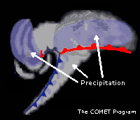 |
|
A stylized mid-latitude cyclone annotated to show the common areas of precipitation. From The COMET Program. |
Occluded fronts, appearing on weather maps as alternating purple triangles and half circles, are those fronts where the cold front has caught up to and overrun the warm front. The weather associated with an approaching occluded front is similar to that of a warm front, with the cloud base slowly thickening and precipitation forming far in advance of the frontal boundary. In contrast to a warm front, the passage of an occluded front is characterized by the heavy precipitation and wind shifts normally associated with a cold front.
The graphic to the left provides a representation of a basic mid-latitude cyclone with its warm front (red half circles on a red line) and trailing cold front (blue triangles along a blue line). It has been annotated to highlight the most likely areas of precipitation. Clouds are represented by the white, gray and blue shading ahead of the cold front, above the warm front and wrapping around the center of circulation. As a result, the overall visual appearance of a mid-latitude cyclone has been compared to a comma and is easily recognized on satellite imagery.
Next: The First Warning
Back: Synoptic Scale Forecasting: A Primer
Restore the Frames Version
© 2005-2006 Mark A. Thornton