The Elements Of An Historic Winter Storm
The Synoptic Picture
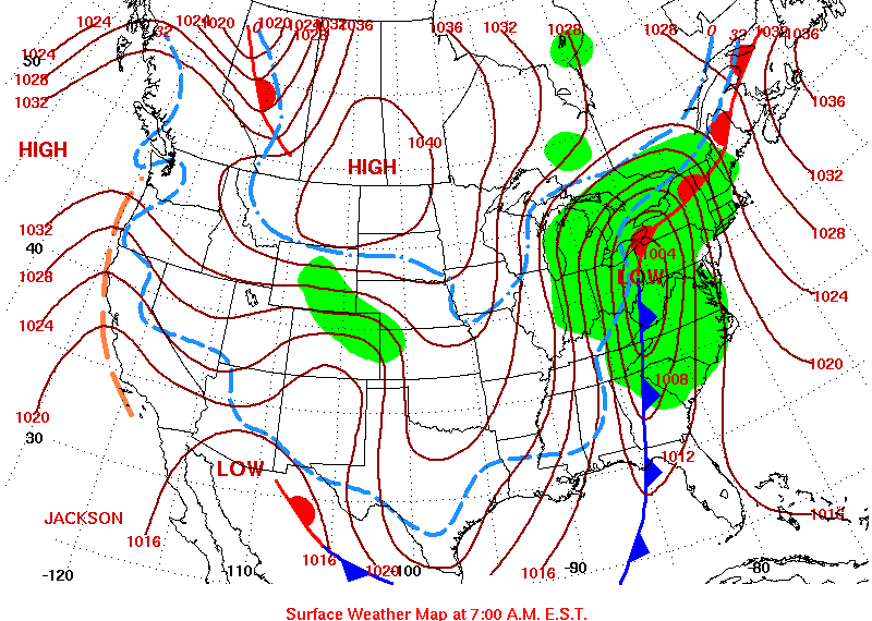
The daily surface weather map issued by the HPC at 7AM EST on December 23, 2004 showed the cyclone over eastern Ohio. Its warm front projected to the northeast along the St. Lawrence Seaway, and its cold front extended far to the south, along the western edge of the Appalachian Mountains. The system was predicted to deliver precipitation (shaded in green) to a vast region of the East Coast. Satellite imagery displayed the signature comma shape of a fully-developed mid-latitude cyclone.
|
|
|
Daily Surface Weather Map from the Hydrometeorological Prediction Center (HPC) for December 23, 2004. |
An MCD Is Issued
The Storm Prediction Center issued MCD #2570 at 12:57 AM CST on December 23, 2004. The warning area covered the majority of three states and portions of four others and predicted:
Significant winter storm will continue to develop north eastward from the Ohio valley into the eastern Great Lakes region through 12Z. Moderate/Heavy snow with hourly rates at times above 1 inch will occur over much of the Indiana/western Ohio and southeastern lower Michigan... with a narrowing transition zone of sleet from central Kentucky northward into north central Ohio...and a zone of freezing rain from portions of middle Tennessee north eastward into southwestern New York/northwestern Pennsylvania.
|
|
|
Warning map from Mesoscale Discussion #2570 issued on December 23, 2004 by the Storm Prediction Center. |

Advection Of Warm And Moist Air
The winter storm was powered by a rich supply of relatively warm, moist air from the Gulf of Mexico. The MCD stated:
Mid-level frontogenesis in the 650-550mb later aided by strong low-mid level warm air advection profile beneath an amplifying negatively tilted upper trough will continue to focus bands of heavy snow over central/southern Indiana and west central Ohio through 10Z...
The advection, or transport, of warm, moist air was aided by a relatively narrow trough of low 850mb heights. A standard pressure level, 850mb, has a representative height of 1,500 meters (4,921 feet) above the surface. The chart of 850mb heights (lower left) at 7PM on December 22nd shows the trough diving south from Canada and centered over the Mississippi Valley. Brisk winds on the eastern side of this trough delivered an abundant supply of Gulf air into the storm. The chart of 850mb winds (lower right) at 7PM on December 22nd indicates the wind over southern Alabama was blowing nearly 65 miles per hour. In fact, the 850mb winds were in excess of 40 miles per hour along the entire length of the East Coast. A twenty-four hour progression of the 850mb trough and its associated winds can be viewed by passing your mouse over the series of observations times below the graphics.
| 850mb Heights | 850mb Winds |
|
|
|
|
|
|
||
|
||


|
Upper Level Support
The previous excerpt from the MCD referred to mid level frontogenesis in the 650-550mb layer. Frontogenesis simply means the generation or intensification of a front. In this instance, the front was located higher in the atmosphere at 650-550mb, a layer typically located from approximately 2,500 to 5,500 meters above the surface.
The MCD also referenced the role played by a negatively tilted upper trough in helping to focus the wintry mix over Indiana and Ohio. In this circumstance, the upper level trough was located at 500mb, or approximately 5,500 meters (18,000 feet) above the surface. A negatively tilted trough is one in which the trough line angles from the southeast to the northwest, such as the one indicated on the chart of 500mb heights (below). A negatively tilted upper level trough contributes to the intensity of a surface low pressure system by providing a source of divergence in the upper reaches of the atmosphere. As was mentioned earlier, a surface low pressure is only able to intensify if a greater volume of air is expelled from the column than that which is entering near the surface.
 |
|
500mb Heights at 7AM on December 23, 2004 showing the negatively tilted upper level trough. Image provided by the NOAA-CIRES Climate Diagnostics Center, Boulder, Colorado. |
Precipitation Type
The MCD warning graphic clearly identified the potential for freezing rain, sleet and moderate/heavy snow throughout the warning area.
South of this area of moderate to heavy snow... a mix of sleet and freezing rain will continue along a 40-60 mile wide corridor from middle Tennessee north eastward into far south western New York and northwestern Pennsylvania through 09Z. Recent 06Z sounding from BNA (Nashville) indicates a substantial elevated warm layer above the shallow subfreezing layer in the post surface cold frontal environment....as a result of the rapid motion of the upper trough and low level cold air advection freezing rain should change over to sleet and eventually light to moderate snow from middle Tennessee northward across north central Kentucky. Further north eastward movement of surface low from south central Kentucky into northwestern Pennsylvania...will result in portions of north central and north eastern Ohio seeing a change from light to moderate snow to freezing rain and sleet.
While the type of precipitation was uncertain, the chart of precipitation rate (in millimeters) for the early morning hours of the 23rd, shows the heaviest precipitation was directly over Ohio.
| Rain | Sleet | Snow |
 |
 |
|
|
Precipitation type based upon temp profile of air column. Adapted from The COMET Program. |
||
The form of precipitation that reaches the ground is determined by the overall temperature profile of the air column. The series of animations to the left display the forces that produce rain, sleet and snow. In all three graphics, air warmer than 32°F is shaded in light red while air colder than 32°F is shaded in blue.
Even if the air aloft is cold enough to support the development of snow, a warmer layer at the surface melts the snow and the precipitation falls as rain.
Sleet and freezing rain result when the air near the surface is less than 32°F but a layer of warmer air exists higher in the atmosphere. Assuming a sufficiently thick layer of warm air aloft, a thick layer of cold air near the surface allows the liquid precipitation to freeze on its journey and arrive at the surface as sleet. Snow that has melted on its way to the surface may not return to snow by passing through a cold layer of air.
If the layer of cold air near the surface is relatively thin, the precipitation reaches the ground as a liquid and quickly freezes on contact. Sleet and freezing rain, which can be particularly destructive to vegetation and power lines, was a prominent feature during the December 2004 winter storm, particularly in north central Kentucky. As the animation on the far right displays, snow reaches the surface only when the entire air column is below 32°F. Once a snowflake has thawed it may freeze if the air column is cold enough, but it can not resume the life of a snowflake.
Temperature
differences of only a few degrees can result in dramatic shifts in the
type of precipitation associated with a winter storm. On the morning of
December 23rd, cold air plunging south from Canada was colliding with
much warmer air from the Gulf of Mexico. The uncertainty of the
temperature profile of the atmosphere over Ohio led the Storm Prediction
Center to forecast
the full range of wintry precipitation.
Meteorologists have a number of tools to analyze the temperature profile of the atmosphere and to assist with predicting the type of precipitation a region is likely to experience. One such method calculates the thickness of the atmosphere from 1000mb (essentially the surface) to 500mb (5,500 meters) in meters. The thickness of the atmosphere from 1000mb to 500mb is directly related to the overall temperature profile, with high values such as 5,700 meters representing a relatively warm layer while values around 5,100 represent a cold layer. Therefore, high values tend to suggest liquid precipitation while a low thickness tends to result in frozen precipitation.
In general, meteorologists use a 1000-500mb thickness of 5,400 meters as a rough dividing line between liquid and frozen precipitation. This forecasting tool should only be used a general guideline however, as it is possible for a warm layer of air to be present in an air column of relatively low thickness. In reality, the 1000-500mb thickness provides only an average temperature of the column rather than a specific profile. The chart of 1000-500mb thickness for the morning of December 23 (below) shows the 5,400 contour (highlighted in red) nearly bisecting Ohio. This was another indicator of the uncertainly of precipitation type for the 23rd.
|
|
|
Chart of 1000 to 500mb thickness for 12Z on December 23, 2004. From the Plymouth State Weather Center. |

A more precise method of determining the temperature profile of an air column is to analyze the temperature at a variety of levels in the atmosphere. The series of images below display the 0°C isotherm (outlined in red) at three levels of the atmosphere-- 700mb (3,000 meters), 850mb (1,500 meters) and at the surface at the specified time.
At the beginning of the time sequence, the temperature at 700mb was well below freezing over all of Ohio. Frozen precipitation was likely to have existed at this level. The 0°C isotherm at 850mb and the surface, however, bisect Ohio from its southwest to northeast corner. Warmer air at 850mb and at the surface increased the potential for a mix of rain, freezing rain and sleet just north of and to the southeast of the 0°C isotherm. By passing your mouse over the observation times below the images, you can watch the overall cooling of the air column over Ohio as cold air advection swept across the state (the southeastward movement of the 0C isotherm tells the story).
| 700 mb | 850mb | Surface |
 |
 |
 |
|
|
||
| Time series of air temperature at 700mb (left), 850mb (center) and the surface (right) on December 23, 2004. The red line represents the 0°C isotherm. Images provided by the NOAA-CIRES Climate Diagnostics Center, Boulder, Colorado. |
| Time: (Mouseover time to change images.) | 12/23 1AM | 12/23 7AM | 12/23 1PM | 12/23 7PM |
Soundings
An additional method of analyzing temperature is through the use of a Skew-T diagram. Twice a day at a variety of weather stations across the country, an instrument package and radio transmitter, called a radiosonde, is carried aloft by a large balloon. As the balloon ascends, the radiosonde measures a number of atmospheric variables including temperature, humidity and barometric pressure, and transmits the raw data to a receiving station. Wind speed and direction is also captured by monitoring the radiosonde's position during its flight. The resulting data is then used to create a SkewT/LogP diagram, commonly referred to as a sounding, which presents the vertical profile of the atmosphere above the station.
The sounding below represents the conditions of the air column above Wilmington, Ohio at 12Z on December 23, 2004. The pressure levels appear along the left side of the chart and temperatures run diagonally from the lower left to upper right. The 0°C temperature line has been outlined in red. The temperature at the surface was -8°C, however, higher in the atmosphere at both 850mb and 750mb the temperature was very near or slightly above 0°C. This condition, where the temperature aloft is warmer than at the surface, is referred to as an inversion. Temperatures aloft hovering just above freezing and the steep decline in temperature below 850mb would have supported snow or sleet at the surface.
 |
|
Skew-T Log P diagram from 12Z on December 23, 2004 from the University of Wyoming. |
The transitions in precipitation type, along with significant accumulations of snow, elevated the status of the December 22-23, 2004 winter storm to historic. The page that follows provides a brief summary of the storm's impact on three Ohio cities.
Next: Meteograms: A Tale of Three Cities
Back: The First Warning
Restore the Frames Version
© 2005-2006 Mark A. Thornton