Synoptic Support
Severe weather watches are the end result of a painstaking analysis of the interaction between synoptic and mesoscale conditions. Consistent with the process used by operational forecasters, our analysis of Tornado Watch #110 will begin with an overview of the large scale features that primed south central Oklahoma for an outbreak of severe weather.
Surface Conditions
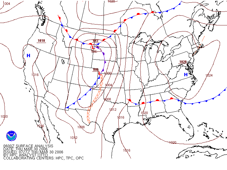
The 6Z (12 AM CST) surface analysis map shows a cold front extending into western Oklahoma from an area of low pressure located in northwestern Kansas. In addition, a dryline, denoted by open half circles along a line, extended southward from this area of low pressure into western Texas. By 12Z (6 AM CST), the area of low pressure had moved into central Nebraska and the cold front was bisecting the Oklahoma panhandle. At this hour, the dryline was observed to have retreated into extreme southwestern Texas. At 18Z (12PM CST) the area of low pressure previously in central Nebraska had closed and shifted south to the Nebraska-Kansas border. The cold front had advanced into west central Oklahoma and had nearly caught up to the dryline, which was now extending northeasterly towards the Oklahoma-Texas border.
 |
|||
|
Surface Analysis Map on March 30, 2006 from the HPC. |
6z | 12z | 18z |
Drylines mark the boundary between warm, dry air originating in northern Mexico and warm, moist air from the Gulf of Mexico. Drylines represent a region of instability and figure prominently in the development of severe thunderstorms in the southern Great Plains, particularly during spring and summer. The important feature of a dryline is a capping inversion, or a layer of warm, dry air aloft that acts to suppress any convection associated with the warm, moist layer below it. The convective inhibition of a dryline, however, is often no match for the intense solar heating of the surface, the synoptic scale lifting associated with approaching frontal boundaries or strong upper-level divergence. Once the inversion gives way, the pathway for deep convection is clear and supercell thunderstorms may result. In addition to their depiction on surface analysis charts, drylines are easy to identify on charts of dew point such as the annotated image below from the Oklahoma Mesonet. Note the twenty degree or more difference in dew points on the east and west side of the boundary.
 |
|
Dew point observations at 350 PM CST on March 30, 2006 from the Oklahoma Mesonet. |
The series of charts displaying surface observations (below) in the two hours before the issuance of the tornado watch shows that the wind in Oklahoma was generally from the south or southeast and temperatures were predominantly in the 60s. Immediately to the west of the approaching cold front, winds were from the northwest and temperatures were generally in the 30s. As the day progressed, the zone of converging winds associated with the cold front moved into western Oklahoma, and provided a source of lift for thunderstorm development.
|
|
|||
|
Surface Weather Plot from the SPC. |
|||

Upper Atmosphere
Dynamics in the upper atmosphere can have a dramatic effect on weather conditions at the surface by contributing to the intensity of surface low pressure systems. The series of 500mb charts (below) shows the structure of the upper-level trough penetrating deeply into the southern Plains. The trough axis became more negatively-tilted and shifted slightly to the east between 15Z and 17Z. Negatively-tilted troughs, characterized by an axis that tilts from southeast to northwest, promote mass divergence in the upper atmosphere to the east of the trough axis. In turn, upper-level divergence contributes to lower surface pressure and provides support for convection in the form of lift. During the duration of Tornado Watch #110, this region of rich upper-level divergence was located over eastern Oklahoma and Kansas.
|
|
|||
|
500mb Heights, Winds, Temperature and Relative Humidty from the SPC. |
|||

Regions of high absolute vorticity, known as vort maxes, may also contribute to the intensity of surface low pressure systems by creating regions of upper-level divergence. The chart of 500mb absolute vorticity (below) shows the location of the strong vort max above southern Colorado at 12Z (6AM CST) on March 30th. The region of upper-level divergence downstream of the vort max extended into northern Oklahoma and Kansas (the core of the vort max is shaded in grey). Upper-level divergence contributed to the magnitude of the forced ascent associated with the advancing cold front.
 |
|
500mb Absolute Vorticity at 12Z on March 30, 2006, from the Plymouth State Weather Center. |
A comparison of the 300mb charts (below) from 15Z to 17Z shows the slight eastward shift of the trough and this associated jet streak stretching over southern Colorado and northern New Mexico. The winds associated with the jet streak were in excess of one hundred knots. The right-entrance and left-exit regions of jet streaks contribute to upper-level divergence, a field that is plotted (in purple) on the SPC's 300mb charts. The region of maximum divergence associated with this jet streak stretched from the Texas-Oklahoma border northward into central Kansas. It also expanded and shifted slightly to the east between 15Z and 17Z.
|
|
|||
|
300mb Divergence from the SPC. |
|||

Using the standard station model to analyze wind speed, the series of 850mb charts (below) shows southerly breezes in the range of forty to fifty knots in the two hour period before Tornado Watch #110 was issued. The wind at this level was advecting a substantial amount of fuel in the form of warm, moist air from the Gulf of Mexico into eastern Oklahoma, just in time to clash with the approaching dryline and cold front.
|
|
|||
|
850mb Heights, Winds, Temperature and Dew Point from the SPC. |
|||

The combined impact of the approaching cold front, the vort max and the negatively-tilted upper-level trough contributed to a decline in surface pressure over much of Oklahoma and Kansas. Although the overall decrease was small, the series of two hour surface pressure change charts (below) between 15Z and 17Z shows the steady decline in barometric pressure over the region.
|
|
|||
|
Two hour surface pressure change from the SPC. |
|||

Forecast
The Daily Forecast Map from the Hydrometeorological Prediction Center for Thursday, March 30, 2006 predicted the possibility of severe thunderstorms for all of Oklahoma with the exception of the panhandle.
 |
|
Daily Forecast Map for March 30, 2006 from the HPC. |
The approaching cold front, the dryline boundary and the upper atmospheric dynamics resulted in an abundance of atmospheric lift over south central Oklahoma. Although deep convection thrives in such conditions, the atmosphere in such an area must also be suitable for severe thunderstorms to develop. Let's take a closer look at the parameters that SPC forecasters used to judge the convective potential of the atmosphere, prompting them to issue Tornado Watch #110.
Next: Analyzing Convective Potential
Previous: Introduction
© 2005-2006 Mark A. Thornton