Dramatic Differences: The Effects of Lake Temperature on Gusty Winds
(published July 2014)
Introduction
The Great Lakes -- individually and collectively -- play a significant role in the region's weather. This is especially evident in the spring and early summer when cold lake waters promote the development of fog, suppress temperatures along the shore, and diminish the potential for strong thunderstorms offshore. One phenomenon of particular interest to sailors is the significant impact a relatively cold lake has on the wind well into the summer months.
An excellent example of this phenomenon occurred on Tuesday, June 17, 2014. During the afternoon, Lake Erie was in the warm sector of a low pressure system located near northern Lake Michigan. The low's warm front was well to the north of Lake Erie, while the system's cold front was approaching northern Ohio from the northwest.

Strong, southwesterly winds ahead of the cold front drove temperatures into the mid- to upper-80s across along the shoreline. The surface water temperatures of Lake Erie were in the mid- to upper- 60s (click here). These relatively cool water temperatures would result in dramatic differences in the wind between Lake Erie's nearshore and offshore waters.
Observations
The Light marking the entrance to the Huron River and Buoy 45005 (the offshore buoy in Lake Erie's western basin) are only 18 nautical miles apart (click here for map). Although these two stations are close together, and were located in the low's warm sector, the wind observations during the afternoon of June 17th were dramatically different (figures 2 and 3). At the Huron Light's shoreside location, the sustained winds ranged from 15 to 20 knots during the afternoon and early evening hours. During the same period, sustained winds at Buoy 45005 hovered around 15 knots, after briefly reaching 20 knots early in the afternoon.


While the sustained winds were relatively similar at the two stations, the observed wind gusts were dramatically different. At noon (16Z), gusts at the Huron Light were reaching 30 knots, while Buoy 45005 was reporting gusts to only 20 knots. At 3 pm (19Z), gusts to 35 knots were observed at the Huron Light, while gusts remained in the 20-knot range at Buoy 45005. A comparison of the wind gust observations indicates the gusts were significantly stronger at the Huron Light during the entire period (click here for graph).
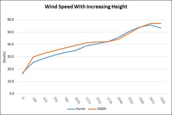
One possible explanation for higher gusts near the Huron Light is that the winds aloft were simply stronger near the shore than over the middle of the lake. An analysis of wind speeds in the air column above each location (figure 4) shows that although the difference isn't significant, the winds aloft over Buoy 45005 were stronger than those above the Huron Light. Let's examine why these stronger winds aloft didn't produce stronger gusts at Buoy 45005
Analyzing Wind Gusts
When preparing a wind gust forecast, meteorologists analyze the temperature and wind profile in a layer of the atmosphere from the surface to approximately 5,000 feet. Typically -- but not always -- the air temperature in this layer steadily falls and wind speeds increase with increasing height. When this occurs, momentum from faster winds aloft mixes to the surface via turbulent eddies, resulting in wind gusts. A forecaster simply has to determine the mean wind speed in the lowest 5,000 feet and estimate the average speed of any wind gusts.
However, a cold lake creates a layer of cold air several hundred feet thick just above the surface, resulting in the creation of a low-level temperature inversion. A temperature inversion is an atmospheric condition where the temperature in an air column warms instead of cools with increased height. Low-level temperature inversions suppress the ability of the atmosphere to mix momentum from faster winds aloft down to the surface, thereby suppressing wind gusts.
Figure 5 shows the lowest portion of the temperature profile of the air column above the Huron Light. The red line represents temperature and the green line shows the dew point. At the Huron Light, the warmest temperature was located at the surface with steadily decreasing temperatures aloft, represented by the steady shift of the temperature trace (in red) to the left. This pattern indicates that a low-level temperature inversion was not present above the Huron Light.


The surface air temperature was colder at Buoy 45005 due to the cooling influence of the surrounding lake waters (click here for chart). In contrast to the air column above the Huron Light, the warmest temperature in the air column above Buoy 45005 (figure 6) was not at the surface, but nearly a thousand feet higher. The rightward path of the temperature trace just above the surface (annotated profile) indicates warming with height, and is the telltale signature of a low-level temperature inversion. This cold layer of air near the surface suppressed wind gusts by inhibiting the momentum associated with stronger winds aloft, preventing them from reaching the surface.

A chart of the air temperature with increasing altitude above Buoy 45005 is shown in figure 7. The pronounced warming -- instead of cooling -- with height just above the surface at Buoy 45005 is easy to recognize. Above the low-level inversion, the temperature profiles at the two locations are virtually identical and show a steady decrease in temperature as altitude increases (click here for chart).
Conclusion
Strong low-level inversions resulting from a relatively cold lake don't develop right at the water's edge. They are typically strongest at the center of the lake, where the water is coldest, and weaken near shore where water temperatures are warmer. In this instance, the movement of very warm air out over the near-shore waters by strong southwesterly winds also inhibited the development of a low-level temperature inversion near the shore. Low-level inversions are very common on all of the Great Lakes, and it’s helpful to consider their effects when early season travels take you offshore.