Lake Erie Ice Transitions
The Buffalo office of the NWS posted two MODIS images showing the transition in ice cover on Lake Erie from February 8 to February 15, 2011 (below).

Accompanying this imagery was the following explanation:
| The image above shows changes in ice cover on Lake Erie from February 8th to February 15th. Strong southwest winds on February 13th-14th may have moved some ice around on the west central portion of the lake. However, below you will find the February 16th Lake Erie Ice Concentration forecast provided by NOAA's Great Lakes Environmental Research Laboratory. As you can see, that west central portion of the lake is not ice free. Part of the reason for the changes in appearance may be due to fresh snow cover on the 8th aging and being deteriorated by a bit of rain which changed the reflectivity, or albedo, of the lake-ice surface by the 15th. |
The GLCFS Lake Erie Ice Concentration forecast valid at 0Z on 2/16/2011 referenced in the explanation appears below. A review of the image indicates that the west central basin was expected to be 20% to 50% covered by ice.
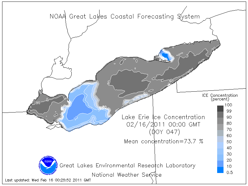
Although rain can clearly reduce the albedo of fresh snow, it is not a valid explanation for the change in the appearance of the lake from February 8th to February 15th. In addition, using a forecast graphic of ice concentration to explain the lake’s appearance on satellite imagery is not appropriate. The correct explanation for the visual transition is simply that the referenced portion of Lake Erie was free of ice.
As the smallest of the Great Lakes, Lake Erie is typically covered by ice by early to mid-January. This is welcomed by residents of Ohio’s lake effect snow belt, as the ice cover significantly reduces the amount of snow they receive during the second half of winter. However, this ice cover is far from static. A relatively-short period of warmer temperatures, sunshine and strong winds can produce cracks and areas of open water as the ice sheets shift in response to the elements. When the conditions are right, surprisingly large expanses of the lake can become ice-free. Click here for an animation of MODIS imagery showing Lake Erie ice cover from January 11, 2011 to February 22, 2011.


A February thaw arrived in northern Ohio just in time for Valentine’s Day. Data from the CMAN station on South Bass Island (above) in Lake Erie's western basin indicates that the daily maximum air temperature moderated into the low forties. This warming trend was accompanied by strong southwest winds.

By the morning of February 15th, a moderate area in the west central portion of Lake Erie was ice free. This observation is supported by a review of the MODIS imagery above and the Ice Analysis published by the Canadian Ice Service on February 14th (above). This imagery is produced by analysts who review a variety of data including satellite imagery and observations from aircraft surveillance.