Superstorm Sandy Produces Havoc On Lake Erie
A Superstorm Is Born
The remnants of Hurricane Sandy roared ashore near Atlantic City, New Jersey at approximately 7:30 pm on October 29, 2012 with sustained winds of 70 knots and storm surge exceeding 10 feet. Dubbed Superstorm Sandy, it ravaged the coast of New Jersey and New York and produced storm force winds as far west as the Great Lakes.
The weak atmospheric disturbance that would later become Sandy developed over western Africa on October 11. Over the next three weeks, the disturbance slowly strengthened as it travelled west towards the Caribbean. At 8:00 am on October 22, 2012, the National Hurricane Center (NHC) categorized the disturbance as a tropical depression (sustained winds were greater than 34 knots). Remarkably, the storm strengthened from a tropical depression to a tropical storm (sustained winds of 35 – 63 knots) in only six hours. Sandy was declared a hurricane (sustained winds => 64 knots) by the NHC at 8:00 am on October 24, as the storm was approximately 80 nautical miles south of Kingston, Jamaica.
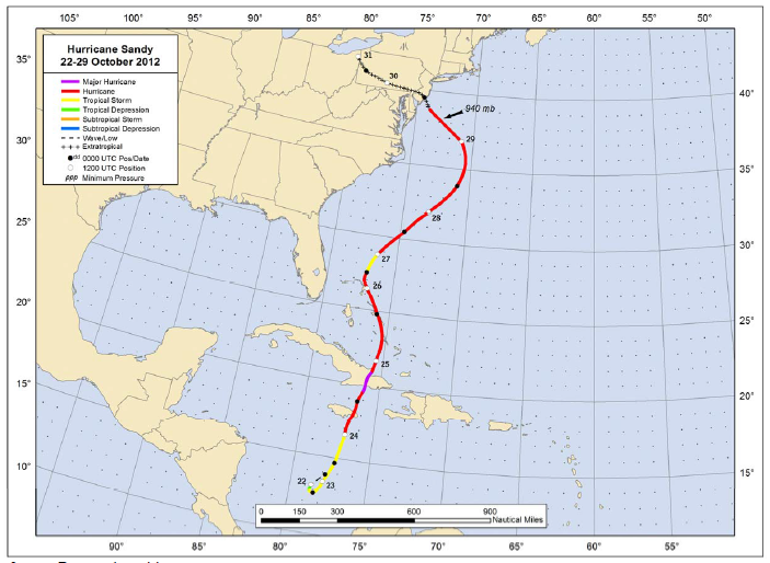
Sandy crossed Jamaica as a category 1 hurricane then, strengthened into a category 3 prior to making landfall in Cuba. Crossing Cuba, combined with unfavorable atmospheric conditions weakened Sandy to a category 1 hurricane as it headed northwest towards the Bahamas. Sandy continued to weaken, losing hurricane status just north of the Bahamas.
This weakening was short-lived, however. Sandy once again reached hurricane status on the morning of October 27, approximately 125 nm north of the Bahamas. Over the next day and a half, Sandy slowly strengthened and moved northeasterly, well offshore from the southeastern United States. Late on October 28, Sandy encountered a strong area of high pressure over the north Atlantic prompting an abrupt left turn towards the New Jersey shore.
After shifting to the northwesterly track, Sandy attained a secondary peak intensity of 85 knots at 8:00 am on October 29, the result of favorable atmospheric conditions and warm Gulf Stream waters. Over the next twelve hours Sandy slowly lost hurricane status, passing over much colder water and encountering much colder air over the northeastern United States before finally making landfall in New Jersey early that evening.
Sandy underwent a complex and perhaps unique meteorological transformation as it approached the New Jersey shore. At landfall, the storm simultaneously possessed characteristics of a warm-core tropical storm and a cold-core garden-variety low pressure system. Read more about Sandy’s unusual transition here. Following landfall, Sandy's remnants drifted northeast over the next two days, finally dissipating over northeast Ohio on October 31, 2012.
Impacts On The Marine Community
Sandy had a dramatic impact upon the recreational boating community. According to Boat US, nearly 65,000 recreational boats -- valued at $675 million -- were damaged or destroyed in New Jersey, New York and Connecticut alone. Even boats stored on shore weren't safe from Sandy’s high winds and storm surge, which reached nearly 13 feet in parts of New York.
Sandy was a very large storm as it approached the New Jersey shore, with tropical storm winds (sustained 35 to 63 knots) extending nearly 425 nautical miles from the storm’s center. The surface analysis issued at 8:00 pm on October 29, 2012 (below) shows the tight barometric pressure gradient extending from Sandy west into the lower Great Lakes.

The primary force governing surface wind speeds is the pressure gradient force -- the change in barometric pressure over a given distance. (Click here for a primer on the forces which control the wind.) Just after landfall, the barometric pressure difference between Sandy and southern Lake Michigan was a remarkable 74 millibars. In order to place this difference in context, the difference on a more typical day is a mere 10 millibars over the same distance. The extreme pressure gradient produced a prolonged period of very strong winds and large waves across the southern Great Lakes, leading to a significant impact on the marine community near Cleveland, Ohio.
The Forecast
The
forecasts issued by the National Weather Service (below) early on October 29th suggested that sustained northerly to northwesterly winds of approximately 50 knots would persist for nearly twenty-four hours across Lake Erie following Sandy's landfall. The corresponding forecasts for wind gusts (click here) across the lake suggested gusts of 70 knots were possible during the same period. In response to the long duration of strong winds, wave heights along Lake Erie's southern shore were expected to reach 20 feet.


Observations
The sustained winds at NDBC buoy 45005, located in Lake Erie's western basin, were more than 40 knots from approximately 9:00 am on October 29 to 5:00 am on October 30, with peak sustained winds of 45 knots observed at 10:00 pm on the 29th. During this same period, gusts remained above 50 knots with a 58 knot gust recorded at 10:00 pm on October 29.


During the period of the highest wind speeds, wave heights remained greater than 12 feet. The highest wave height associated with Sandy -- 14 feet -- was observed at approximately 4:00 am on October 30th.
Sustained wind speeds and gusts observed by the automated weather station (CND01) near downtown Cleveland were much higher than those observed at buoy 45005. Sustained winds of 50 knots or greater persisted for nearly 9 hours, with the highest sustained winds of 55.5 knots occurring a little after 10:00 pm on October 29. Gusts at CND01 remained higher than 60 knots for several hours from late on the 29th into the early hours of the 30th, with a maximum gust of 67.3 knots observed at approximately 9:30 pm on October 29.

NDBC 45005 is the only weather station that measures wave heights on Lake Erie. While the highest official wave height associated with Sandy was 14 feet, it is likely that higher wind speeds (and longer fetch) near Cleveland produced much higher waves. In addition, the prolonged strong northerly winds produced a displacement -- a temporary increase in water level -- of 2 to 3 feet along Lake Erie's southern shore from late on the 29th to mid-day on the 30th.
Superstorm Sandy Destroys Two Marinas
Although the level of destruction pales in comparison to the damage along the shore of New Jersey and New York, nearly 30 boats were sunk and many more were severely damaged at Edgewater State Marina and Whiskey Island Marina by the strong winds and associated waves of Superstorm Sandy.


According to eyewitnesses, both marinas were severely damaged by a combination of towering waves (estimated at 20 feet) that surged over protective breakwalls, winds at or above 50 knots for nearly 10 hours and a 2 to 3 foot rise in the level of the water. Under the relentless onslaught, boats broke free as pilings gave way, docks failed, and dock lines parted. These free-floating battering rams careened around the marinas serving as an additional destructive force.


The partial failure of Whiskey Island Marina's entrance breakwall (in blue on the satellite image above) allowed the frothing surge of Lake Erie to easily enter the marina. The resulting waves, combined with the overall rise in the water level, lifted a few of the floating docks higher than the pilings that were designed to retain them. The unrestrained docks and attached boats moved unencumbered around the marina, producing even more destruction.
Conclusion
Boaters in the Great Lakes, particularly those in the Cleveland area, will remember Superstorm Sandy for many years to come. Even one year later, many are astonished that a landfalling storm nearly 500 miles away was capable of producing such unprecedented destruction across the region. Below are several photographs of Edgewater State Marina and Whiskey Island Marina that were taken a few days after destruction wrought by Superstorm Sandy.
PHOTOGRAPHS
EDGEWATER YACHT CLUB/EDGEWATER MARINA


PHOTOGRAPHS
WHISKEY ISLAND MARINA


Interested in reading and learning more about marine weather? A few times each year, I publish an article on an interesting marine weather event. Click here to subscribe to my 'no spam' email distribution list.